DCist’s Classical Music Agenda. I’ve been going to the free Sunday concerts at the National Gallery of Art, but I had no idea that LOC had free classical concerts too. More wonderful stuffing for my classical music schedule.
Cassava, Jailbreaks, and Politicians
Death and chaos land the Philippines back in the world headlines: first the kids killed by contaminated cassava, then the bloody Abu Sayyaf jailbreak attempt. Key quote from the Philstar editorial:
Throughout the day the nation had to listen to the demands of people who had just killed three jail guards and were on trial for multiple murder and kidnapping. They even found allies in the usual publicity-hungry politicians and human rights advocates who were falling all over themselves to get into the picture and sabotage police negotiations. And we wonder why the country is turning into a terrorist paradise.
Also see Soliven’s column: “A murderous jailbreak try that turned into a disgusting circus.” (Read those Philstar links quickly, before their stupid link expiration.)
Walking Home on a Sunny Sunday
(I’m actually cheating a bit; I took these photos on a walk about a month ago, and am only showing them now because I forgot to take my camera when I walked the same route home today. That’s why the second photo doesn’t include the lovely St. Patrick’s Day Parade which went down Constitution Ave this afternoon.)
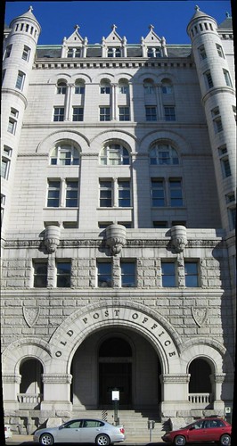

The Old Post Office Tower.
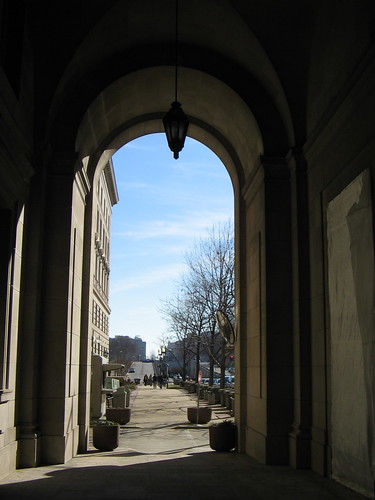
Looking South towards The Mall through an arch in Federal Triangle.
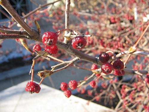
Shriveled berries in the Smithsonian Butterfly Garden.
What’s On My Bed

When Enterprise Tried to Do Religion
In the Enterprise episode “The Forge”, Archer and T’Pol talk about the teachings of Surak:
“Over the centuries, his followers made copies of his teachings.”
“Let me guess: With the originals lost, whatever’s left is open to interpretation.”
“You find this amusing.”
“I find it familiar.”
Is this what passes for criticism of religion in Star Trek? Archer seems to have invoked the popular “copy of a copy of a copy” fallacy, to which I recently responded in Metafilter thusly:
Someone who makes a claim like this either hasn’t done his homework or is deliberately using a contentious straw man. The bibles we read today are accurate (or at least close-to-accurate) copies of manuscripts close to the originals that were circulated through the early church. The authenticity of these documents is backed up by archaeological evidence and simple church tradition. There hasn’t been a slow degradation through centuries because biblical scholars base their translations on the earliest possible material that they can. If changes ever crept into the process, they would have been noticed immediately against the backdrop of thousands of other copies of the same manuscript.
The different translations you see circulating today are updates for language or paraphrases of hard-to-translate Greek and Hebrew, with footnotes for any possible discrepancies. It doesn’t make sense to accuse Christians of using a Bible whose meaning has been deteriorated by time; we’re essentially reading translations of the same texts used by Christians at the start of the church — although now we have the benefit of footnotes, printing, binding, concordances, and the intarweb.
Also see this TrekNation review of “Chosen Realm” — another attempt to introduce religion into a Trek plotline — in which the reviewer exclaims, “The level of contempt suggested here for organized religion is staggering.”
Yet another good thing about Enterprise being cancelled, I suppose: we’re spared these Star Trek writers’ ham-fisted attempts at contemptuous, off-base critiques of issues of faith.
Gout in my Shoulder
Update: I got blood work done and my uric acid levels are well within normal limits, so I do not have gout, and the shoulder pain was most likely muscle spasms. Since then I’ve eaten oysters, clams, mussels, crabs, anchovies, sardines, mackerel, and other seafoods in mass quantities, without any pain or inflammation. Please ignore the rest of this entry.
DEPRECATED INFO [[[
For your reference: Gout.
Monday, 9pm: Russell, visiting from California, takes me and my coworkers out to dinner at Mimi’s and Johnny’s Half Shell. I consume a bottle of Yuengling, a few bites of calamari, six raw clams, a bowl of extra-spicy filé gumbo with mussels, and a glass of white wine.
Monday, 11pm: I go to sleep, lying on my left side under the sheets. Uric acid, introduced by an increased intake of purine-rich alcohol and shellfish, begins to form crystals in my bloodstream.
Tuesday, 2am: Uric acid crystals accumulate where my sleeping position has caused blood concentration to pool: my left shoulder.
Tuesday, 5am: I am awakened by a dull, steady ache in my left shoulder and arm. My first thought is that a heart attack can often manifest as pain in the left arm, but then I remember an old softball injury in my shoulder from grade school. I dismiss it as the old pulled muscle acting up again and attempt go back to sleep.
Tuesday, 6am: The pain is now so intense that I am groaning in bed and cannot sleep. Painkillers do not help.
Tuesday, 9am: Painkillers begin to kick in, but I call in sick. I still do not realize that I have gout, though a long draught of water helps the pain somewhat.
Tuesday, noon: Late for work, I suddenly remember that my father has a history of gout, and has warned me that it can be passed down to other males in the family. I have indeed gotten similar episodes of foot and joint pain after eating large quantities of codfish and steak in the past.
I conclude that I have had a gout attack in which the pain hit my shoulder rather than my big toe (a more common spot for gout attacks), and am kept in a state of reasonable comfort by acetaminophen through the rest of the day. Note to self: cut down shellfish intake.
]]]
Memetic Mappage
Here’s a fun way to waste your day on Google Maps: try to find (1) the farthest possible destination from your hometown, and (2) the absolute longest possible trip you can make through the US. Both my linked attempts are limited to within the USA, but Canadian destinations are also a possibility. Can you go farther?
(Yes, you can do this with MapQuest or Yahoo Maps, I suppose, but Google Maps is easier and more fun to use; just type in your To and From cities and away you go.)
The Other Manilas
Fun fact: There are at least two places named “Manila” in the USA: Manila, Arkansas and Manila, Utah, both small towns. Does your home city have any heartland echoes?
Update: Okay, my coworker Keith has sent me the ultimate list of US geographic features named “Manila,” via the USGS Geographic Names Information System (GNIS). They do so much more than just earthquakes! You can search the GNIS here.
Begonia, Snowballs, and a Wiggle
Just got back from New Jersey. This quick snapshot en route did not get posted because my password in the blog settings was wrong. Anyway, here are some photos from the weekend.

Closeup of a spiny begonia leaf.
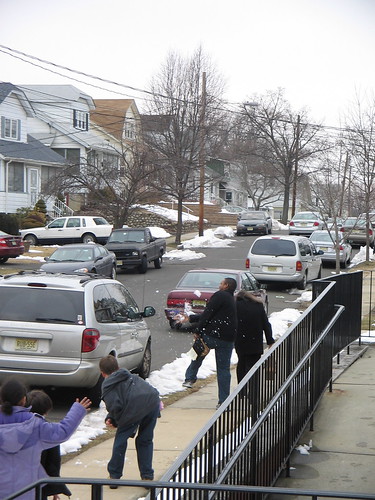
Snowball fight outside First Baptist Church in Union, NJ.
Stereo wiggle of the view from inside Art School at Old Church, where Amy has two small paintings up at a juried show there.
Bus to New York
In a couple of hours, I’m going up to New York to see my luv for the weekend, but instead of the usual Amtrak, I’m trying something cheaper — one of those “Chinatown buses.”
This trip will take me from DC to New York Penn Station, a 4.5 hour ride, for just $20 one way, (as compared to 3 hours for $75 by train). For schedule and convenience reasons, however, I’m taking a train back home on Sunday, but the savings are still considerable. If the bus ride and service is better than Greyhound’s (shudder), this may become my standard mode of transportation to hop north in the future.
I’ll try and post photos en route.