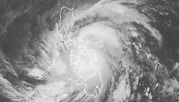
Typhoon Haiyan (PAGASA name Yolanda) struck the Philippines on November 7th, devastating islands in the Visayas, flattening whole towns and villages, and killing thousands. With sustained winds of 195 mph and gusts up to 235 mph, it was the strongest tropical cyclone on record to make landfall.
My comparison of aerial typhoon damage photos from Guiuan with older satellite imagery from Google Earth :
2003 Google Earth image of #Guiuan compared with @TeamAFP #Hainan/#YolandaPH post-typhoon photo taken yesterday. pic.twitter.com/xl0wgE5OGm
— brownpau (@brownpau) November 10, 2013
Instagram user macmaloon posted videos from Tacloban showing just how strong the wind and rain were — before the full brunt of the storm had even struck: 1, 2, 3:
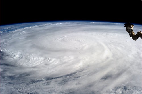
NASA astronaut Karen Nyberg (who just returned to Earth yesterday) photographed the typhoon from orbit aboard the International Space Station:
This composite satellite image was from two geostationary spacecraft, MTSat-2 and Meteosat-7 (Copyright 2013 JMA/EUMETSAT):

-
BBC: Philippines destruction ‘absolute bedlam’ — feature includes before/after images, satellite views, survivor stories, accounts from a missionary providing aid, and reports from Vietnam. Also see As it happened – Philippines typhoon disaster.
-
Typhoon report from Jeff Masters of Wunderground. Sustained wind from the typhoon after landfall was apparently equivalent to at least an EF3 or EF4 tornado.
-
Capital Weather: Chasers document “ghastly” scene, raw damage images and video, and discussion on reasons for the damaging winds and storm surge causing such a high death toll.
-
Washington Post: Videos show Typhoon Haiyan’s charge across Philippines.
-
Reuters photo slideshow: initial photos of typhoon damage in and around Tacloban.
-
The Atlantic In Focus: Super Typhoon Haiyan Devastates the Philippines.
-
Storify collections from Cebu Daily News and Weather Stories.
-
“The last time I saw something of this scale was in the aftermath of the Indian Ocean tsunami.” – UN disaster aid official Sebastian Rhodes Stampa.
-
Aerial photos of typhoon damange on Malapascua Island. (I visited Malapascua on a dive trip in 2005.)
-
Armed Forces aerial photos of Guiuan, Eastern Samar, one of the first and hardest hit locales.
-
Buzzfeed interview with a storm chaser in Tacloban. “And then, at the height of the storm, the bay rose up like a tsunami, swallowing the downtown area….Our hotel flooded so fast that guests in first-floor rooms were caught off guard. Their doors were wedged shut by rapidly rising water, turning their rooms into death traps.”
-
Channel News Asia: Philippines helpless in face of powerful storms, say experts.